


The streets:
The streets that delimit the block are drawn according to a pre-established plan, respecting the orientation that was
given to the streets at the time of the foundation of the city (around 22° Northeast). They intersect at right angles and
form rectangular city blocks.
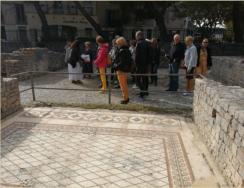
The block discovered at the "Clos de la Lombarde" is about 25 X 100 meters. The streets are of different widths, between
8 and 12 meters. Along the north side of the block, an alley quickly turns into a cul de sac.
The streets were not paved. They were simply covered with soil and gravel and sometimes had cart strips. At the "Clos
de la Lombarde", two streets were lined by a sidewalk covered with a portico.
Street
A
parallel
to
the
Via
Domitia
seems
to
have
been
built
at
the
end
of
the
Republic
and
could
be
contemporary
with
the
urbanization
of
"Clos
de
la
Lombarde".
It
ran
along
House
II
to
the
west
and
the
House
with
the
Porticoes
to
the
east.
It
was
8.20
meters
wide.
It
was
regularly maintained.
It
provided
pedestrian
pathways
along
the
facades
of
buildings that bordered it.
A
portico
resting
on
the
west
wall
of
the
House
with
the
Porticoes
sheltered
passers-by,
merchants
and
craftsmen who found refuge there.
A central tread was dedicated to the circulation of carts and
trolleys. Some slabs were found with deep ruts.
Street C intersected Street A at a right angle and ran along the House with the Porticoes on its north side. It originally
measured 5.80 meters in width. It allowed access to neighboring homes but above all had a very complex sewer system
to collect rainwater and sewage improving the comfort of the houses that bordered it.
By the middle of the first century, the bordering houses IV and VI encroached onto the street before occupying its full
width turning it into cul-de-sac.
Towards the end of the second century, an artisanal establishment settled on the street in its western part, destroying
the street but using the main sewer to evacuate its waste water.
Street B, facing west - east and cutting Street A in a right angle was only partially uncovered and has not been excavated
to date.
Street
D
parallel
to
Via
Domitia
was
south
-
north.
On
its
west
side,
the
baths
were
located.
House
I
stood
to
the
east.
The
street
was
11.20
meters
wide.
It
allowed
the
circulation
of
carts
and
trolleys
on
a
central
tread.
The
porticoes
which
bordered
it
on
both
sides
provided
shelter
for
the
pedestrians
walking
there.
This
street
is
still
under
study
and
no publications have been released yet.
Rainwater and wastewater networks:
It was only during the first century AD that a water distribution system was installed under each of the streets.
The sewers were made of flat tiles (tegulae) on which walls made of squared rubble were supported. The ducts were
covered with tiles, vaults or slabs. The covers fell victim to "materials reusers" and have often disappeared.
Openings were installed at certain places to allow cleaning and maintenance work.
The collector of street C received about twenty sewers from adjacent houses. It led into the main collector of Street A.
A large collector and secondary sewers were also
found under street D.
The sewage system in the antiquity used the natural
slope of the ground. It takes the form of masonry ducts of rectangular section or terracotta pipes, but usually lead, put
end to end.